The Southwestern United States, also known as the Southwest, is a geographic region of the United States that includes Arizona and New Mexico, along with adjacent portions of California, Colorado, Nevada, Oklahoma, Texas, and Utah. Its also home of some of the most beautiful national parks, and offers amazing views to vaste nature spaces.
USA
25th of July 2023
|
Preview | Pop-up preview
Download
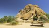
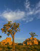
Image: 000076156
Joshua trees and rock formations in Joshua tree. Joshua Tree National Park, California, USA...
25.06.2005
Primoz Jeroncic PhotoSI
By: Primoz Jeronci
|
|
|
Preview | Pop-up preview
Download
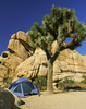
Image: 000076157
Idilic camping place in middle of desert. Camp is located in Hidden Valley on Northwest part of Josh...
25.06.2005
Primoz Jeroncic PhotoSI
By: Primoz Jeronci
|
|
|
Preview | Pop-up preview
Download
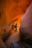
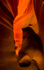
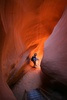
Image: 000076158
Lower Antelope Canyon (or The Corkscrew) section of the Antelope Canyon. Antelope Canyon is slot can...
29.06.2005
Primoz Jeroncic PhotoSI
By: Primoz Jeronci
|
|

|
Preview | Pop-up preview
Download
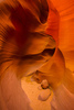
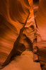
Image: 000076159
Lower Antelope Canyon (or The Corkscrew) section of the Antelope Canyon. Antelope Canyon is slot can...
29.06.2005
Primoz Jeroncic PhotoSI
By: Primoz Jeronci
|
|
|
Preview | Pop-up preview
Download
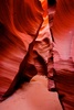
Image: 000076160
Lower Antelope Canyon (or The Corkscrew) section of the Antelope Canyon. Antelope Canyon is slot can...
29.06.2005
Primoz Jeroncic PhotoSI
By: Primoz Jeronci
|
|

|
Preview | Pop-up preview
Download
Image: 000076161
Lower Antelope Canyon (or The Corkscrew) section of the Antelope Canyon. Antelope Canyon is slot can...
29.06.2005
Primoz Jeroncic PhotoSI
By: Primoz Jeronci
|
|
|
Preview | Pop-up preview
Download
Image: 000076162
Lower Antelope Canyon (or The Corkscrew) section of the Antelope Canyon. Antelope Canyon is slot can...
29.06.2005
Primoz Jeroncic PhotoSI
By: Primoz Jeronci
|
|
|
Preview | Pop-up preview
Download
Image: 000076163
Lower Antelope Canyon (or The Corkscrew) section of the Antelope Canyon. Antelope Canyon is slot can...
29.06.2005
Primoz Jeroncic PhotoSI
By: Primoz Jeronci
|
|
|
Preview | Pop-up preview
Download
Image: 000076164
Lower Antelope Canyon (or The Corkscrew) section of the Antelope Canyon. Antelope Canyon is slot can...
29.06.2005
Primoz Jeroncic PhotoSI
By: Primoz Jeronci
|
|
|
|
|
Preview | Pop-up preview
Download
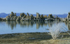
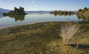
Image: 000076167
Mono Lake is located just east of small city Lee Vining, California, USA. John Muir described Mono B...
04.07.2007
Primoz Jeroncic PhotoSI
By: Primoz Jeronci
|
|
|
Preview | Pop-up preview
Download
Image: 000076168
Mono Lake is located just east of small city Lee Vining, California, USA. John Muir described Mono B...
04.07.2007
Primoz Jeroncic PhotoSI
By: Primoz Jeronci
|
|
|
Preview | Pop-up preview
Download
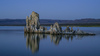
Image: 000076169
Mono Lake is located just east of small city Lee Vining, California, USA. John Muir described Mono B...
04.07.2007
Primoz Jeroncic PhotoSI
By: Primoz Jeronci
|
|
|
Preview | Pop-up preview
Download
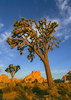
Image: 000076170
Sun is rising behind Joshua trees and magnificent rock formations in Joshua Tree National Park, CA, ...
24.06.2007
Primoz Jeroncic PhotoSI
By: Primoz Jeronci
|
|
|
Preview | Pop-up preview
Download
Image: 000076171
Sun is rising behind Joshua trees and magnificent rock formations in Joshua Tree National Park, CA, ...
24.06.2007
Primoz Jeroncic PhotoSI
By: Primoz Jeronci
|
|
|
Preview | Pop-up preview
Download
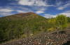
Image: 000076172
Lava flows from Sunset crater volcano. Sunset crater volcano is situated in Sunset Crater volcano Na...
25.06.2007
Primoz Jeroncic PhotoSI
By: Primoz Jeronci
|
|
|
Preview | Pop-up preview
Download
Image: 000076173
Wukoki pueblo is small Sinagua Indians village located in Wupatki National Monument. Sinagua Indians...
25.06.2007
Primoz Jeroncic PhotoSI
By: Primoz Jeronci
|
|
|
Preview | Pop-up preview
Download
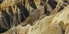
Image: 000076174
Blue Mesa badlands and washes in Petrified Forest National Park. Blue Mesa is crown jewel of Petrifi...
25.06.2007
Primoz Jeroncic PhotoSI
By: Primoz Jeronci
|
|
|
Preview | Pop-up preview
Download
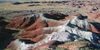
Image: 000076175
Painted desert bandlands are located on North part of Petrified forest National Park. Petrified Fore...
25.06.2007
Primoz Jeroncic PhotoSI
By: Primoz Jeronci
|
|
|
Preview | Pop-up preview
Download
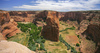
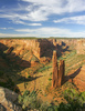
Image: 000076177
Labyrinth called Canyon de Chelly is really several canyons, which include Canyon de Chelly and Cany...
26.06.2007
Primoz Jeroncic PhotoSI
By: Primoz Jeronci
|
|
|
Preview | Pop-up preview
Download
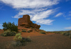
Image: 000076178
Spider rock is an 800 foot sandstone spire that rises from the canyon floor at the junction of Canyo...
26.06.2007
Primoz Jeroncic PhotoSI
By: Primoz Jeronci
|
|
|
Preview | Pop-up preview
Download
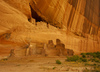
Image: 000076179
White house ruin below in Canyon de Chelly. White house was built by ancient Puebloan people and oc...
26.06.2007
Primoz Jeroncic PhotoSI
By: Primoz Jeronci
|
|
|
Preview | Pop-up preview
Download
Image: 000076180
White house ruin below in Canyon de Chelly. White house was built by ancient Puebloan people and oc...
26.06.2007
Primoz Jeroncic PhotoSI
By: Primoz Jeronci
|
|
|
Preview | Pop-up preview
Download
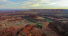
Image: 000076181
Sunset over Canyonlands, Utah, USA, from Dead Horse Point in Dead Horse Point State park, Utah, USA....
29.06.2007
Primoz Jeroncic PhotoSI
By: Primoz Jeronci
|
|
|
|
|
|
|
|
Preview | Pop-up preview
Download
Image: 000076186
Lower Antelope Canyon (or The Corkscrew) section of the Antelope Canyon. Antelope Canyon is slot can...
29.06.2005
Primoz Jeroncic PhotoSI
By: Primoz Jeronci
|
|


)
)
)
)
)
)
)
)
)
)
)
)
)
)
)
)
)
)
)
)
)
)
)
)
)
)
)
)
)
)